The City of Cape Town has urged residents, the business community and all stakeholders to comment on the proposed Mobility and Access Plan for the Cape Town CBD.
This plan is included as part of the draft local spatial development framework (LSDF) for the Cape Town CBD that is available for public comment until 11 May 2025.
There will also be some online information sessions, the first of which is taking place on Tuesday, 15 April 2025.
The first draft LSDF and proposed Implementation Plan was made available for public comment in September and October last year.
The City refined these draft documents, taking into account the comments received during the first round of public participation.
The proposed Implementation Plan consists of programmes, projects and actions to be implemented by various City departments with support from the private sector and other inter-governmental stakeholders in various priority precincts within the CBD.
The MMC for Urban Mobility Rob Quintas says residents are now also encouraged to comment on the draft Mobility and Access Plan specifically designed for the CBD.
This plan is in its formative stage, and is shared for a first round of public comment as an annexure to the draft LSDF. Another round of public participation will follow in coming months, taking into account the input we receive during this current commenting period.
The Mobility and Access Plan seeks to optimise the use of existing transport infrastructure to enable many more people to move around the CBD.
It proposes some bold interventions to make the CBD more pedestrian-friendly and to improve access to and within the area. The intention is to create a walking and cycling network that is efficient and well-connected, one that users find safe and convenient and will improve access.
ALSO READ: Car free Sundays on Bree Street
“Ultimately, those who work and live in the CBD, and visitors, must find it easy to get to their destinations and a pleasure to move through the area.”
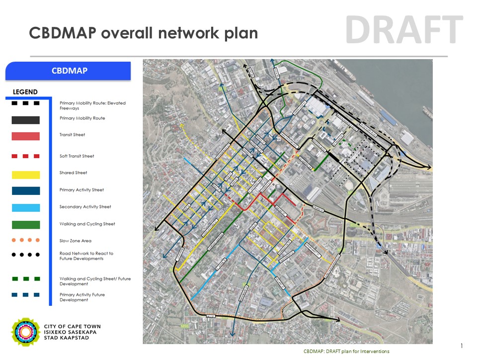
CBD Mobility and Access Plan (CBDMAP)
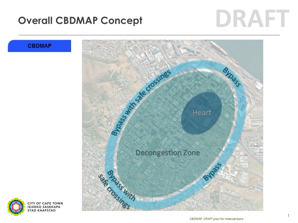
The main ideas are to improve walkability in the heart of the CBD, around the public transport stations and terminus; to promote walking and cycling within the CBD by creating a decongestion zone; and to divert through-traffic onto bypass roads, with targeted safe crossings for pedestrians and cyclists.
The decongestion zone would include superblocks, similar to those in Barcelona, but relevant to the local context.
The strategic objectives are as follows:
- Prioritise public transport along transit streets, amongst which Darling and Adderley Streets, and related street sections
- Re-prioritise lower order streets from vehicular traffic to pedestrian-friendly spaces to encourage walking and dwelling
- To support internal economic growth and social activity along activity streets, such as Bree, Long and Loop Streets
- Retain the majority of vehicular movement on high-order bypass routes, such as Buitengracht, Buitensingel, Mill, Tenant and Christiaan Barnard Streets, and the foreshore freeway precinct
- Develop a seamless network that will make walking and cycling easy, safe and attractive
Thus, the plan proposes a road network plan that identifies the role, function, and typical characteristics of the roads within the CBD study area; and a schedule of routes to be partially pedestrianised. The intention is for the majority of vehicular traffic to travel around the CBD with no parking or cycling along these bypass routes.
The plan also identifies routes where public transport will be given priority. It proposes reallocating the street space to reflect the priorities of pedestrians, in particular for commuters using public transport, public transport vehicles, cyclists, and activities supporting economic activity.
Conflict between vehicular movement and pedestrians is addressed through superblocks in the historic core, and through traffic calming and control measures at major pedestrian crossings, such as those found along Strand Street.
The City also intends to develop a parking plan for the CBD to facilitate a gradual transition from private vehicle dominance towards a more people-centred environment that encourages walking and cycling and the use of public transport services. The parking plan will elaborate on the provision of park-and-ride facilities on the periphery of the CBD to ensure the area becomes as car-free as possible.
Foreshore Feasibility Study
A key priority is to develop an integrated transport and land use solution for the Foreshore Precinct. A feasibility study is under way and has not been concluded as yet.
The current freeway viaducts carry significant traffic during the morning and afternoon peak periods. The scoping study is aimed at developing the optimum transport and land use solution to ensure long-term investment and economic growth of the Central City and Atlantic Seaboard, while maximising the precinct’s public amenity value and development potential.
“The primary objective as it relates to pedestrians and cyclists is to, ideally, arrive at a ‘car free’ CBD in future where the freeways, major mobility routes, and minor mobility routes facilitate vehicular access to and from the area, and where the inner-grid of lower order streets gives priority to pedestrians and cyclists. This plan must be supported by a parking plan. I want to reiterate that the transition to this vision will not happen overnight and will have to be sequenced with the improvement of public transport services, in particular the restoration of the passenger rail service in coming years.”
The proposed Mobility and Access Plan, as well as the draft LSDF, are available on the City’s website at: www.capetown.gov.za/haveyoursay