

South Africans are urged to brace themselves as cold, wet and windy weather is expected over large parts of the country from today until Thursday.
The South African Weather Service (SAWS) has attributed the inclement weather to a cut-off low-pressure system expected to make landfall over the western parts of the country.
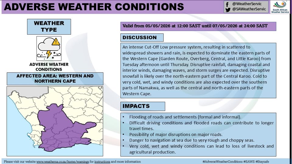
“The system is expected to initially affect the Western Cape, Northern Cape, and Eastern Cape before spreading eastwards across the central and eastern interior from Tuesday afternoon into Wednesday morning,” SAWS said.
Residents in affected areas are advised to prepare for continued rainfall, strong winds, and a noticeable drop in temperatures over the coming days.
“Widespread rainfall is anticipated over the Western Cape and Eastern Cape, extending into the Free State, with 24-hour rainfall accumulations likely to exceed 100–200 mm in places. This may result in widespread flooding. In addition, damaging winds and very rough sea conditions are expected, particularly along the south coast of the Western Cape and the Eastern Cape coastline,” the weather service warned.
The Western Cape Department of Mobility has since advised the public to exercise caution when travelling, especially in areas prone to flooding or reduced visibility.
Maxine Bezuidenhout, the Department’s Traffic Chief, says roads will be slippery and has stressed the importance of adhering to road safety measures during adverse weather conditions.
“Both motorists and pedestrians are urged to exercise extreme caution in the current wet and rainy conditions. Roads are slippery, visibility is reduced, and stopping distances are longer. Drivers must reduce speed, increase following distances, and ensure their vehicles are in a safe condition. Pedestrians should remain visible and only cross at safe, designated areas. Road safety is a shared responsibility, and responsible road use will save lives,” Bezuidenhout stressed.
