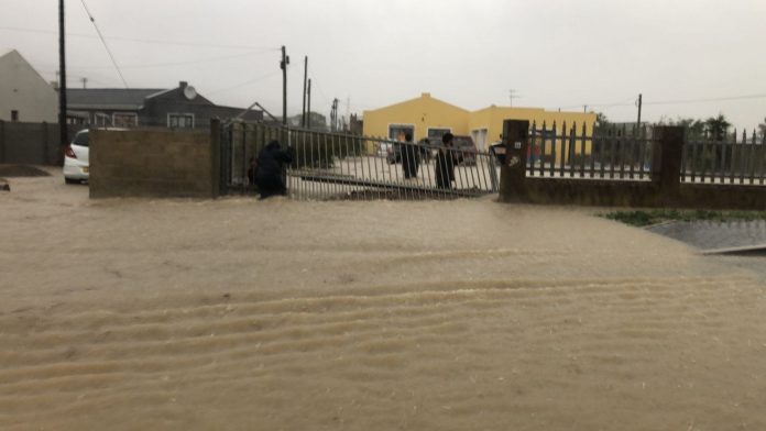
City Cape Town and Provincial disaster officials have reported flooding in numerous area overnight as heavy rains and gale force winds tormented the province overnight, with more rainfall expected on Monday.
Flooding in informal areas such in Shuku-Shukma & Sir Lowry’s Pass Village, Rasta Camp, Riemvasmaak, 7de Laan Sandvlei Macassar, Old Faure Driftsands, Mfuleni, and Bellville South are being attended to.
Flooding of formal housing occured houses in several areas including Durbanville, Bo-Kaap, Schaapkraal, Bellville South, Belhar, Sandvlei Macassar, Strand, Gordons Bay, Knorhoek.
Emergency services had to assist four people trapped in a house in Strand and evacuated them to Strand Fire station.
STRAND. #CapeStorm pic.twitter.com/0KvBWf78rO
— Shane Jeremy Hendricks (@ShaneJeremy1) September 25, 2023
The roof was also blown off a private property in the CBD, while a NUTEC dwelling in Hout Bay was also damaged due to wind.
The City says assessments will continue to determine the exact damage.
People are urged to stay off the roads as numerous roads have been flooded, and trees have been uprooted blocking roadways.
Cape Town – Sea Point: Fallen Tree #CapeStorm pic.twitter.com/PhzuvGLkKt
— TrafficSA (@TrafficSA) September 25, 2023
At Wemmershoek Dam, the sluice gate has been opened to mitigate downstream flooding. The Lourens and Eersteriver have burst its banks. There are also reports that a small river in Stanford burst its banks, flooding the town.
This is the mostly mild Klein River where the Cape Epic entered Stanford earlier this year. Torrential rains overnight have turned it into a monster. Homes have been lost, cars swept away… it's really bad. pic.twitter.com/k86TMEPyAT
— Peter Bruce (@Bruceps) September 25, 2023
Technicians are also contending with weather related power outages in Eastridge, Mitchells Plain, Philippi, Gugulethu, Eastridge, Steenberg, Wetton, Bellville, Plattekloof, Green Point, Pinati Estate.
The restoration of power may take time and work on faults related to damaged overhead lines is also dependent on weather conditions improving due to safety considerations. Eskom’s load-shedding can also impact service request volumes and restoration times.
The torrential rain is continuing for the rest of Monday, with an Orange level 9 warning for Rain with isolated severe thunderstorms leading to widespread flooding/flash flooding,
mudslides and major travel disruptions is expected in the Overberg and southern Cape Winelands spreading to the Garden Route coastal areas into today.
There is also a Yellow level 4 warning for Rain with isolated leading to localised flooding/flash flooding and disruptions to municipal essential services is expected over the Central Karoo, northern Cape Winelands, southern West Coast and
City of Cape Town today.
In addition, an Orange level 6 warning for Interior Winds leading to damage to settlements is expected over the Garden Route, Overberg, City of Cape Town, southern West Coast district and Langeberg municipality remains in place for today.
There is also an Orange level 6 warning Wind and Waves leading to disruption of ports and small harbours is expected between Table Bay and Plettenberg Bay and Cape Columbine.


