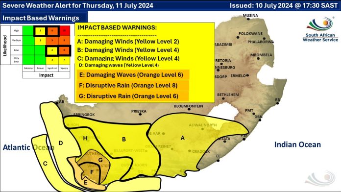
Western Cape Premier Alan Winde said all hands are on deck to deal with the impact of more inclement weather. This as an orange level 8 warning for disruptive rain leading to flooding and possible mudslides was issued for Thursday for the City of Cape Town, Drakenstein and Stellenbosch municipalities. A warning of damaging waves also remains in place until Friday.
At least 15,000 residents have been impacted by the weather so far, with 4,500 displaced.
Earlier today 😱 insane!
in Newlands when the river burst its banks. 9 July 2024 @kaapstadStay safe all. Our thoughts this week with everyone without a home and warm bed. 🙏🏼 🕯 #capeStorm please reach out where you can?
credit 📹 Madison
grateful_girl_94 pic.twitter.com/kvkVmuK5da— ᑕᗩᑭE TOᗯᑎ (@CapeTown) July 9, 2024
During a media briefing held on Wednesday, Winde stressed the importance of adhering to warnings and tips:
“Please, when an official comes to you and says you need to evacuate, please make sure that you listen. If an official says to you please don’t use this road, don’t use the road. If there is no official and you see lots of water going across the bridge, don’t brave that bridge,” said Winde.
READ MORE: CAPE STORM: Some schools will be closed Thursday
Meanwhile, Local Government MEC Anton Bredell. He shed light on the current situation. A series of cold fronts have been sweeping its way through the province since early Sunday, continuing until Friday.
THOUSANDS AFFECTED
“We’ve received a lot of rain and severe winds that damaged a lot of informal dwellings. Over 1,000 (dwellings have been damaged) in Ward 99, in Khayelitsha. We currently sit with 4,000 – 5,000 informal dwellings that have been damaged and 15,000 affected people,” said Bredell.
Snow in Montagu, Western Cape, South Africa 🇿🇦 pic.twitter.com/PcwCXGgUzq
— Melissa Le Roux (@MelissaLeRoux24) July 9, 2024
The Western Cape Head of Disaster Management, Colin Deiner confirmed that 70 agencies are working together to provide shelter, humanitarian aid, emergency response and more. Deiner explained that the various organisations and governmental departments are ready for Thursday’s cold front:
“The orange level 8 warning on Thursday means that it is a severe impact event. We had an incident earlier this year that was a level 9, in April. Due to the fact that we have already had a lot of rain, we have saturated ground. We are seeing this in an extremely serious light,” expressed Deiner.


